- Description
Description
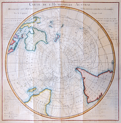
Carte De l’Hemisphere Austral
Fascinating large format map of the Southern Hemisphere, including New Zealand, Australia, New Guinea, Borneo, Madagascar, part of Africa and South America and more.
This map was created to detail Jacques Cook’s voyages in the region and also shows the tracks of the major voyages of exploration in the Southern Hemisphere from 1595 to 1775. Including the voyages of Mendana (1595), Quiros (1606), Le Maire and Schoeten (1616), Tasman (1642), Halley (1700), Roggewein (1722), Bouvet (1738-39), Carteret (1767), Wallis (1767), Byron (1768), Bouganville (1768) Cook (1770-75), and others.
By Jacques Nicolas Bellin, a French mapmaker, was named the hydrographer (chief cartographer) to the French Navy, and later, the Official Hydrographer to the French King. During his term as Official Hydrographer, the Depot was the single most active center for the production of sea charts and maps, including a large folio format sea-chart of France, the Neptune Francois. He also produced a number of sea-atlases of the world, e.g., the Atlas Maritime and the Hydrographie Francaise. These gained fame, distinction, and respect all over Europe and were republished throughout the 18th and even in the succeeding century.
Related Products
