- Description
Description
Description
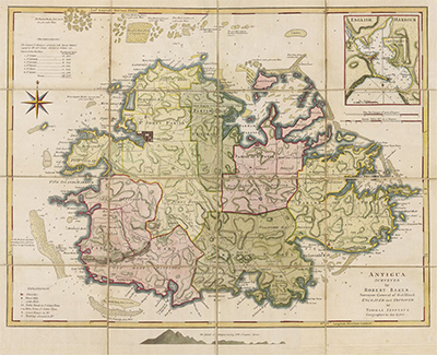
Map of Antigua from ‘The West-India Atlas’.
Surveyed by Robert Baker, Surveyor General of that Island. Engraved and improved by Thomas Jefferys, Geographer to the King.
Divided into Parishes with a key at the top left observing the size of each parish in acres.
At the top right is a magnified view of English Harbour, showing Freemans bay and a section of land for the use of the Navy.
This is a fine art reproduction of a map published 1775.
NB: This Fine Art Reproduction can be printed to any size, please contact us to discuss bespoke sizes to meet your needs.
Each print is embossed with our stamp, guaranteeing quality and authenticity.

