- Description
Description
Description
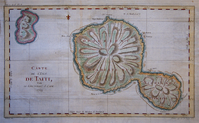
Carte de L’Isle de Taiti
Original engraving from Cook’s Voyage showing one of the earliest maps of the Tahiti. The map shows the volcanic mountains and coral reefs around the islands.
Cook arrived at Otaheite 13 April 1769, to measure the transit of Venus across the sun’s sphere which was to take place on 3 June, an event which occurred only twice within eight years and once every 120 years.
By Jacques Nicolas Bellin for “Histoire Generale Des Voyages” and printed between 1758 -1775.
Bellin (1703 – 1772), a French mapmaker, was named the hydrographer (chief cartographer) to the French Navy, and later, the Official Hydrographer to the French King. During his term as Official Hydrographer, the Depot was the single most active center for the production of sea charts and maps, including a large folio format sea-chart of France, the Neptune Francois. He also produced a number of sea-atlases of the world, e.g., the Atlas Maritime and the Hydrographie Francaise. These gained fame, distinction, and respect all over Europe and were republished throughout the 18th and even in the succeeding century.
Related Products
